Watershed Wednesdays
New Year, new initiatives!
For 2021, we wanted to kick off a fun new educational series called Watershed Wednesdays! On Wednesdays, we will make a post on social media with information relating to watershed systems, and how they might relate to the Little River Watershed.
January 13, 2021: Watersheds
So of course, we thought we should start off by explaining….just what exactly IS a watershed??
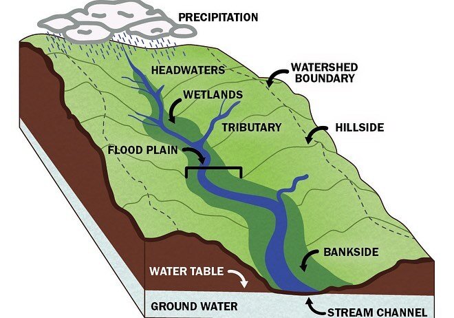
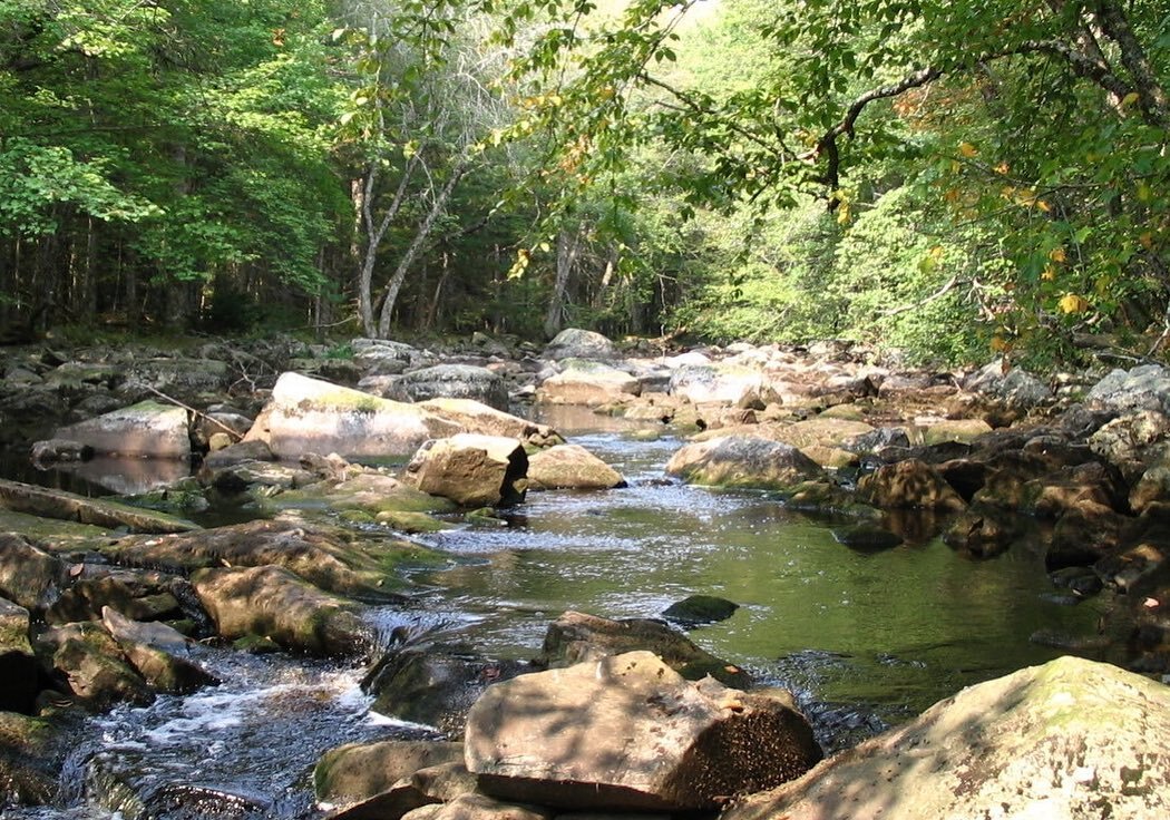
A watershed is an area of land that drains rainwater or snow into one location, a common point, such as a stream, lake, or wetland. Topography, or the physical characteristics of an area, determine the watershed boundary lines. A watershed boundary can pass through county, state, and even federal lines. Also, larger watershed systems can contain smaller watersheds, but we will talk more about that later!
January 27, 2021: Little River Watershed
We are kicking back up our Watershed Wednesday initiative and this week we want to highlight the Little River Watershed!
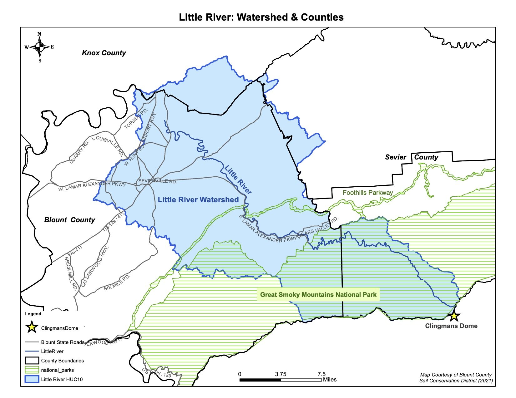
The Little River's headwaters begin on the eastern slope of Clingman's Dome in the Great Smoky Mountains National Park and flows 60 miles through portions of Sevier, Blount, and Knox County before joining the Tennessee River in Knoxville. As we previously learned in the first Watershed Wednesday post, a watershed is an area of land that drains into a common location; the Little River Watershed drains a 380 square foot area before flowing into the Tennessee River, also called Fort Loudon.
The Little River watershed is particularly important because not only does it provide drinking water for a majority of Blount County, the pristine waters in and directly downstream of the park allow for a diversity of species to thrive, such as hellbenders, smallmouth bass, and darter fish. As the river flows closer to Knox County it becomes more impacted by pollutants, such as sediment runoff and failing septic tanks, which is why it is critical to protect the watershed as a whole, because if the land becomes impaired, the waters will also become impaired.
Check out the map of the Little River Watershed to see if you can tell if you live within the Little River Watershed boundaries. If you don't live within the Little River watershed, you can visit our website via the link in our profile to find out your own watershed address!
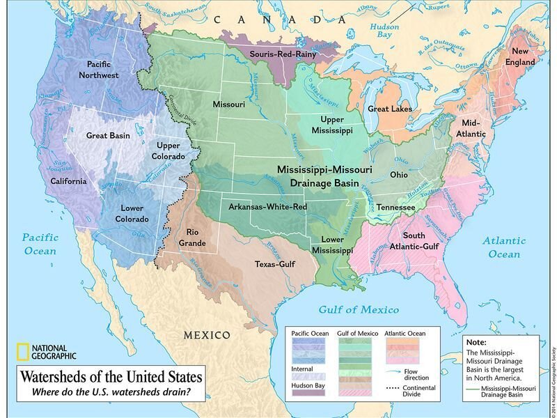
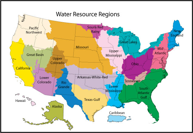
February 17, 2021: HUCs
During our past few Watershed Wednesdays, we have talked about what a watershed is, but this week we want to go over how watersheds are categorized. Watersheds are classified by their HUC number. A HUC number, or Hydrologic Unit Code, is how a particular watershed is identified. The contiguous United States is divided and sub-divided into successively smaller hydrologic units, which are classified into six levels:
2-digit HUC first-level (region), 4-digit HUC second-level (subregion), 6-digit HUC third-level (accounting unit), 8-digit HUC fourth-level (cataloging unit), 10-digit HUC fifth-level (watershed), 12-digit HUC sixth-level (subwatershed). There are 21 watershed regions in the US, including the Caribbean.
It might be a little confusing, but the smaller the HUC number, the larger a watershed is.
For example, the Little River watershed is a HUC 10 watershed (0601020101) and is nested within a HUC 8, the Watts Bar watershed (06010201). Watts Bar is within a HUC 6 watershed, the Upper Tennessee watershed(060102).
By defining watersheds at different scales, we can better understand how land use and management affects water quality.
Do you know what watershed you live in? If not, click here to find out!
March 3rd, 2021: Foam
This watershed Wednesday we want to talk about something people often see more frequently as they get out and around water bodies for the season. While this phenomenon may look gross, it's generally from a naturally occurring process...you guessed it, it's FOAM! When you see this dirty brown, foamy stuff at a lakeshore, most people are concerned, and rightfully so! But typically, the foam we see on bodies of water is from aquatic plant matter (such as algae) that die off and decompose and then release a variety of organic compounds. The wind and movement of water then cause bubbles which can turn into foam.
The good news is the foam substance does not necessarily indicate poor water quality; in fact, trout will often hide in the foam line or concentrations.
Of course, if this foam smells perfumy, and you believe there is the possibility for the dumping of chemicals, it is a serious issue for water quality, and there is cause for concern. If you think someone may have dumped something harmful into the water, contact one of the following numbers depending on where you live.
Blount County: 865- 273-5756
City of Alcoa: 865-380-4820
Knox County: stormwater@knoxcounty.org

The foam in question on the Little River
March 17, 2021: Algal Blooms
Today we love to see green, and usually in nature, green is indicative of good things like new growth or a healthy ecosystem, but sometimes nature can trick us, and what we think is normal can be a sign of something potentially harmful. So, on this Watershed Wednesday, we want to talk about the green stuff in nature we need to be aware of, algal blooms.
Algae is a critical part of aquatic ecosystems, providing food and sometimes shelter for a variety of species, and phytoplankton, a type of algae, is estimated to create nearly half of the oxygen in the world. But sometimes, under certain conditions, there can be a rapid overgrowth, or a 'bloom' of the algae, which then causes an imbalance to the ecosystem, and can potentially have some harmful consequences.
Harmful algal blooms(HABs) are generally caused by an increase of nutrients(nutrient loading), like nitrogen from excess fertilizer runoff, in conjunction with warm temperatures in water. While algal blooms can be a variety of colors, typically the algal blooms you would see in Tennessee would be green or greenish-blue, would have a scummy look, or may look like spilled paint, usually are in slow-moving water, and may have a bad odor. These HABs can be harmful not only to aquatic life but to humans, pets, and livestock as well if exposed.
We want to also make the distinction that not all algae you see in water systems are bad, but simply to help bring awareness to the ones that can be. All the photos in this post are examples of harmful algal blooms.
Here are some tips to do your part to help reduce the occurrence of algal blooms:
-Always pick up your pet waste
-Have your septic tank regularly checked and pumped
-Use phosphate-free detergents, soaps, and household cleaners
-Test your soil before fertilizing to make sure you're not adding an excess of nutrients
And if you think you've spotted a harmful algal bloom, contact the TN Dept of Health at Waterborne.Health@tn.gov, or call
615-741-7247
March 24, 2021: Cairns
This watershed Wednesday, we want to 'rock' your world and want to talk about something that can sometimes be a somewhat divisive topic.
Rock stacks or sometimes called rock cairns, historically have been used to mark graves, paths, or ceremonial sites. In fact, today in some National Parks, rock stacks are used as trail markers set up by a Park Ranger, and while they may have been put there intentionally on a trail to guide you on your hiking path, they do not serve the same purpose when they are stacked at the edge of a body of water. And while rock stacking might seem harmless and might even a be meditative practice for some, these rock stacks actually have harmful consequences for certain aquatic species and their habitat.
When you remove these rocks from their natural location, you are potentially removing an important creature's home base and safety zone. Some fish lay eggs in the small spaces under rocks, so when these are moved, their nest is destroyed, and small fish are possibly killed. Additionally, Eastern Hellbenders, the largest salamander in the United States(they can get up to 2 - 2.5 feet long!) live in the crevices under rocks and will potentially make their home under the same rock for years. When you move these rocks, you are destroying their safe space and leaving them exposed to predators. We are fortunate enough to have Hellbenders documented living in the upper, pristine stretches of the Little River, and as they are a near-threatened species, we want to do everything we can to protect them. So, it is important to not move rocks for stacking, to create artificial dams, or to take one home to use as a doorstop.
As a reminder, it is illegal in GSMNP to move rocks in the river or streams. So please, when you get out in nature, leave the rock stacking to the experts and make sure to leave no trace behind you.
April 7, 2021: Stormwater
With all the rain we've had recently, you may have seen some flooding in places or even had some flooding issues where you live, which may have led you to consider, “how is water is supposed to properly drain in a city?” and “how can we help prevent these extreme flooding issues from reoccurring?”
So today, on this Watershed Wednesday, we want to talk about stormwater. Stormwater is exactly what you'd think it would be, any precipitation that falls from the sky, such as rain, hail, or snow. After a rain event, some of the water soaks back into the ground or evaporates from the heat of the sun, but that, of course, is not an option when water hits an impervious, or impenetrable surface, such as asphalt. That is why in cities, there are storm drains to help properly drain the water runoff from areas where the water can't infiltrate, such as roads and parking lots.
Why should we care about stormwater? Well, most importantly, the water that drains from yards, roads, farms, mountains, etc., will eventually end up in our creeks, rivers, and lakes, which then eventually can be treated and used for our drinking water. In short, whether we think about it or not, stormwater affects everyone.
There are some ways you can help reduce runoff and help promote infiltration into the ground on your property. Installing green infrastructures, such as a rain garden or a bioswale, installing permeable pavement surfaces, or even using a rain barrel, can all help reduce excess water from pooling, and that, in turn, can help from overwhelming stormwater drains during a big rain event. To learn more about making your yard or property more stormwater friendly, you can visit the University of TN Smart Yards website!
April 21, 2021: Point Source Pollution
As it is Earth Week, this Watershed Wednesday we want to get down to the nitty-gritty and talk about pollution. Pollution is the introduction of harmful materials into the environment. There are two types of pollution, point, and non-point source, but today, we want to talk about point source pollution. Point source pollution(PSP) is easily identifiable and comes from a single source. Some examples of point source pollution are smokestacks, water drainage pipes, factories, and large animal feed operations. Pollutants from PSP have potentially damaging effects on the environment and in the watershed because these harmful materials are directly released, and typically unfiltered and unconstrained.
As an environmental organization, it is important to us that we bring up these topics, to help educate our community so that we can better understand these issues and attempt to prevent them from happening in the future. Please remember to contact your local county government if you notice any signs of pollution that could be deemed as harmful to people or the environment. Some suggestions are on our website under the River Resources tab.
We can all do our part to help keep the Little River and Planet Earth a happy and healthy place for this generation, and the next 🌎🌱♻️
April 28th, 2021: Nonpoint Source Pollution
In honor of the last week of Earth Month, we want to continue to talk about pollution on this Watershed Wednesday in hopes that we can help to prevent it from occurring in the future.
Last week we talked about point source pollution, which is easily identifiable and comes from a single source, but this week we want to talk about nonpoint source(NPS) pollution, which conversely comes from multiple sources or areas and is not easily identifiable.
Nonpoint source pollution is primarily caused when rainfall flows off the land, roads, buildings, and other features of the landscape. The runoff from the rain washes things like excess nutrients (fertilizers, pesticides, etc.), organic waste(manure & dog droppings), toxins(oil from cars, chemicals from various industries), and sediment from the land, into our water systems.
Things that can help with nonpoint source pollution include applying lawn and garden chemicals sparingly, picking up your pet's waste, properly disposing of oil, antifreeze, paint, or other household chemicals, preventing soil erosion on your property by planting ground cover plants, and having your septic system checked pumped every 3 to 5 years.
We hope that by bringing awareness to the types of pollution in our waters, we can help to prevent these types of pollution from continuing, and help to keep our watershed as healthy as possible for years to come!
May 19th 2021: Bioindicators
During April for Earth Month, we talked about pollution and how that can affect our water bodies and the watershed, but on this Watershed Wednesday, we want to talk about some of the things that help us to gauge the health of our environment and water systems, bioindicators.
Bioindicators are living organisms that give us an idea of the health of an ecosystem. They can be animals, plants, or even microorganisms. They have been called the "canary in the coalmine" because if these species start to decline or disappear, it is indicative that the overall ecosystem has an issue, and its health may be declining. But conversely, if these species are present, it can mean that the ecosystem is healthy and thriving.
We are fortunate to have some healthy water systems in this region, and some of the bioindicators you might see in the area (and in the Little River) include salamanders, mussels, caddisflies, and darter fish. A prime example of a bioindicator species found in the Little River Watershed is the Eastern Hellbender. Because these creatures breathe through their skin, they are extremely sensitive to changes in water quality. So, if the quality of the water starts to degrade in an area where Hellbenders are typically found, then their population can start to decline. That is why it is up to us to help preserve these delicate ecosystems so that we can not only protect these indicator species but have healthy, clean waters now and for future generations.
June 9th, 2021: Reservoirs
As the weather starts to warm up and we begin to make summer plans, you might be considering a trip to a local lake or reservoir. On this Watershed Wednesday, we're going to talk about reservoirs, the difference between a reservoir and a lake, and why they are important to the communities they surround.
A reservoir is an artificial lake where water is stored, usually formed by constructing dams across rivers. A reservoir can also be formed from a natural lake whose outlet has been dammed to control the water. Conversely, a lake is formed when surface water fills a low spot and can be made up of groundwater seeps, melting ice, streams, or rain. Dams are typically built on a river to help control flooding issues, to provide water for crops, and in more recent times, to generate electricity from hydroelectric power.
Hydroelectric dams were constructed by Tennessee Valley Authority (TVA) along the Tennessee River system to help prevent flooding issues as well as to provide clean, renewable energy to citizens of the region back in the 1930s. Because of TVA, today we have a variety of reservoirs in the region that have important aesthetic, recreational, and economic impacts on the community. Without them, we wouldn't have the renewable power most homes in the Tennessee Valley use every day or the miles of navigable rivers for boating, fishing, and other recreational activities.
Did you know, the Little River drains into the Fort Loudon Reservoir, on the Tennessee River, in Knoxville?
Do you have plans to get out to your local lake or reservoir this summer?
August 18th, 2021
With all the rain we’ve had recently, you may have noticed some soggy ground and maybe some ponded water in areas. So today, we want to talk about something that can be beneficial to both the environment and property owners alike. On this watershed Wednesday we want to talk about rain gardens!
When houses and roads are built, more rainwater runoff is generated than when the land was a forest or meadow.
A typical house and driveway will shed about 1,000 gallons of runoff in an inch of rain. Our area saw 2-4 inches yesterday, and how many houses are there in Blount County? You do the math - that's a lot of water!
Rain gardens can help catch that runoff or ponding water with native plants, which then help filter the stormwater and reduce the amount of pollutants entering our watershed. They also help provide habitat for native species and overall better the ecosystem. Catch the rain and grow native plants in rain gardens like these designed and installed by Dr. Julie Konkel and Dr. Andrea Ludwig at the Blount County Soil Conservation District office.
You'll be doing the Little River a favor too!
September 8th, 2021
You may have experienced high amounts of rainfall recently, or have seen the news about some destruction that flooding has caused around Tennessee and other parts of the country recently, so this Watershed Wednesday, we want to discuss the topic of floods.
A flood event is an occurrence where water overflows to an area of land that is normally dry. We should also note that a floodplain is an area of low-lying ground adjacent to a river, formed mainly of river sediments, and is subject to flooding.
Flooding and floodplains are a natural part of a river system, and light flooding can be a common occurrence as there is natural expansion and contraction of the river as seasons ebb and flow. While sometimes floods can be an intense and destructive force, usually, these processes are undisruptive events in the natural world.
Humans and animals alike are attracted to rivers and floodplain areas due to the nutrient-rich content of the soil, but living in these areas comes with some compromise as these are the areas prone to flooding. We are better at controlling river flow and flooding since the introduction and installation of dams and levees, but it still can happen, especially in areas with smaller creeks and rivers. We are, however, seeing more flash floods and intense storms in recent years due to climate change, because hotter air holds more moisture, and dries out the soil.
One of the major ways we can hope to mitigate these issues is by reducing greenhouse gases so we can in turn hope to stop global warming. At a municipal level, we can help with this issue by limiting development in floodplains, decreasing the amount of impervious pavement and having more green space and porous surfaces in a city, and by having proper stormwater management plans in place.
April 20th, 2022
We’ve got some good news! Our Watershed Wednesday posts are making a comeback in honor of Earth Week!
And today we want to talk about litter in our watersheds, specifically why does litter that is on the ground have an impact our water systems?
When we have heavy rain and storms, water will move trash and debris that is on the land into our waterways, this can then detrimentally impact the quality of our waters and the creatures that inhabit them. Litter that ends up in our waters can potentially leak toxic chemicals, harm our wildlife or disrupt delicate aquatic ecosystems.
Not only will the trash impact the health of your local watershed, it can then lead to pollution further downstream. Did you know rivers are the primary source of plastic pollution to our oceans?!
Our watersheds are an important part of a system that is delicate and needs to be dutifully protected.
So remember, anything that happens on land can have just as much impact, if not more, to our rivers, lakes, streams and oceans!
May 4th, 2022: Stormwater detention basins
This watershed Wednesday we want to talk about stormwater dentention basins. You might have seen these before if you live in a subdivision or near a shopping center and never thought twice about them, but these structures provide an important function in a urban world by helping to ‘catch’ storm water off of impervious surfaces.
Dentention basins help store the stormwater after a heavy rain event. They retain the water in a basin so it can help slow runoff going downstream and prevent flooding issues.
There are wet detention basins, also called retention basins or wet ponds, that hold water permanently or dry basins, that are normally dry and hold water after a heavy rain but will eventually drain or dry out.
The wet retention basins can be planted with native plants and are a great habitat for native species as well. They also have an added benefit of helping to filter the water before it potentially flows out.
These infrastructures are helping to control runoff in areas where otherwise flooding would be huge issue!
We recently had the oppurtunity to partner with Native Plant Rescue Squad to save some native plants before construction began at a basin at Eagleton Academy! These plants will be potted and be able to be planted in a new home at a later time!
Remember we are all downstream from someone!
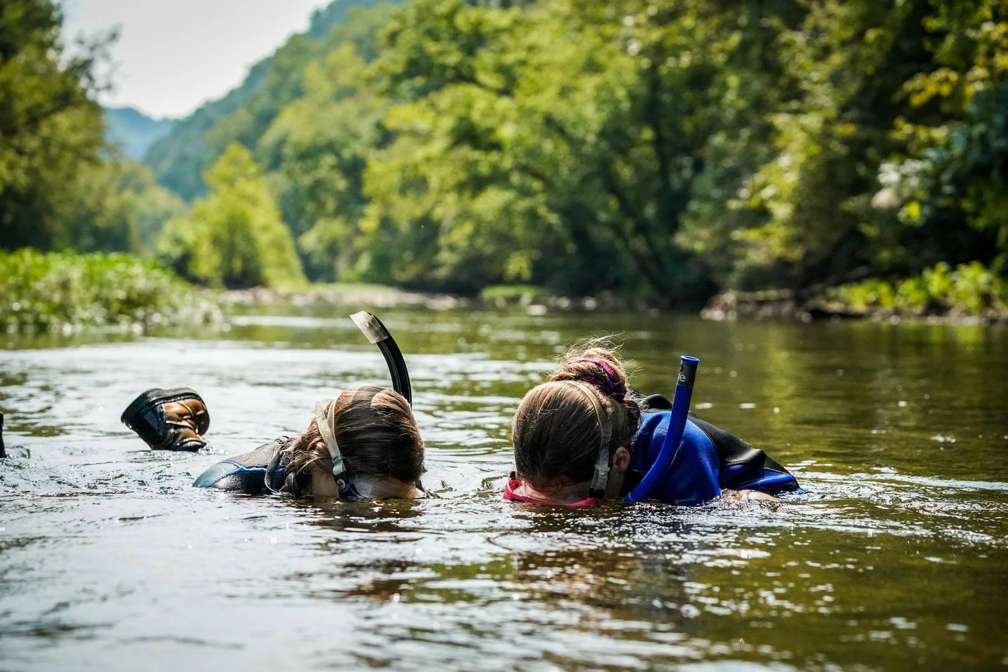
May 18th, 2022: Macroinverterbrates
If you’ve ever been out by the creek or river, you may have noticed some critters moving around in the water. Usually what you are seeing is something called a Macroinvertebrate, and they are a super important part of a watershed systems! So this watershed Wednesday we want to talk about them and why they are so important!
Macroinvertebrates are organisms that lack a spine and are big enough to be seen with our eyes alone. Some of these creatures might live all their life in the water, while some types might live in water for a time, perhaps in their larval state, and then move to land once they mature to mate or lay eggs.
Common macroinvertebrates you might find would be mayflies, crayfish, snails, dragonflies, and beetles 🪲
These are important creatures not only because they are a food source for fish and other species in a watershed, but they are also considered to be bioindicators of the waters they exist in. Macros are generally not very tolerant to polluted water systems, so if you’re seeing these critters in your creek, you probably have fairly healthy water!
We found a lot of neat macros at our last Stream School, including a fishfly in various stages of life!
Education Materials
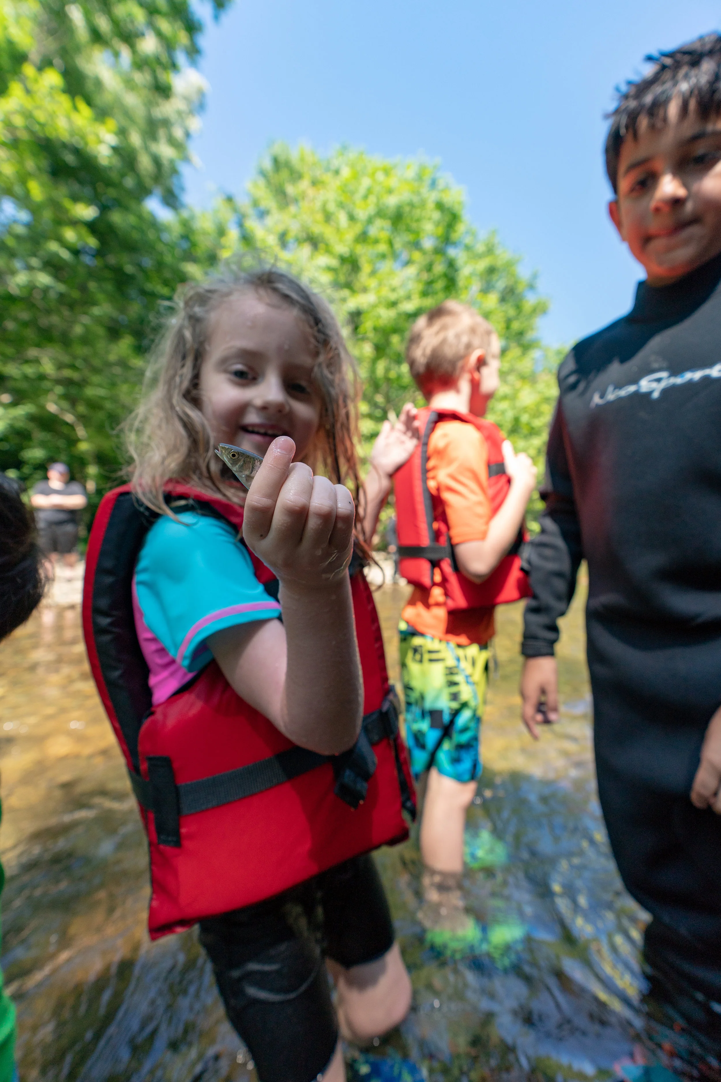
stream school for kids
Stream School for Kids is an outdoor educational program that provides a fun introduction to stream science for kids and their parents. Geared towards students fourth grade and up, the program is based on STEM (Science, Technology, Engineering, and Math) concepts and incorporates environmental, chemical, and aquatic sciences.
The event includes four main stations: Watershed Systems /Water Cycle, Fish Identification, Macroinvertebrates, and Water Chemistry/Water Quality.
We begin the three-hour class by discussing Little River and its watershed: where does it originate; how many miles does it flow, why is it important? Next, we discuss river flow (why flow changes based on geography and weather, and why it is important) We also discuss what all is impacted by the watershed, the fish and the birds, insects and amphibians that rely on the river for a water source, and how we as humans impact and are affected by out water systems.
Students also learn about the water cycle, and how water cycles from the land to the rivers and streams, and then back again. It is important for students to make the connection that water is in a constant cycle to understand that pollution in one area can then later affect another area.
Once the students know how that rate might change if the river wasn’t as wide, if the river was deeper, or if we just had a lot of rain, students can understand that flow isn’t constant; it is a function of water volume and velocity, and it changes with weather, human interactions and topography, and it impacts water quality, organism habitat, sediment transport, and dissolved oxygen levels.
From these different stations kids can begin to understand the importance of clean water in our watershed systems and what all organisms are affected by clean or polluted systems.